Feature engineering guided by geology is a key step in applying machine learning to mineral exploration. Combined with mineral systems, it strengthens mineral prospectivity analysis by linking geological knowledge with data-driven methods. Traditional prospectivity studies often rely on a single dataset—such as geophysical or geochemical data—and manual interpretation, which limits their ability to capture the complex processes controlling ore formation.
The newer approach begins with feature engineering, where raw geological data from remote sensing, geophysics, geochemistry, and geology are transformed into quantified meaningful variables. For instance, remote sensing data are used to derive alteration indices. Geophysical datasets highlight structural features such as lineament density and orientation, while geochemical data define anomaly contrasts and multi-element patterns. Geological information contributes distances to faults, intrusions, or favourable rock units. Each feature is linked to a specific mineral system component—fertility, fluid pathways, traps—ensuring geological relevance and statistical robustness. Instead of raw datasets, these engineered features become inputs for mineral prospectivity models, maintaining alignment with ore-forming processes and improving predictive reliability.
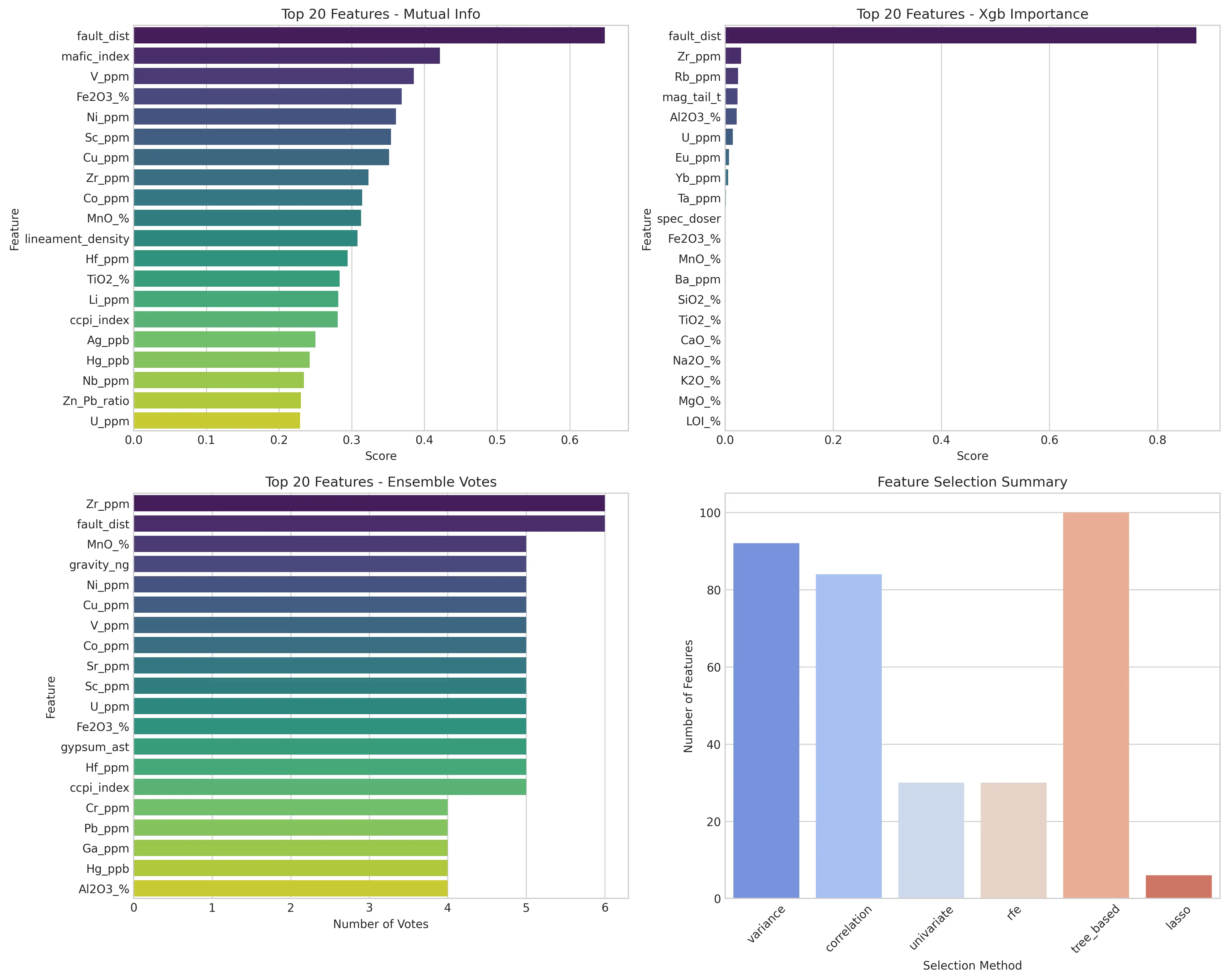
The next step is the feature importance analysis, which ranks variables by their contribution to prediction. Several methods are used: Mutual information captures non-linear relationships with mineralisation; Random Forest and XGBoost rank features by their influence on model gain and decision splits; and permutation importance measures accuracy loss when a feature is shuffled. These techniques identify the most influential variables and enable comparison with mineral system concepts. In orogenic gold deposits, for instance, alteration indices or structural corridors usually rank highest, confirming consistency with mineral systems framework.
The final step, feature selection, retains only the most informative variables while removing redundancy. Variance and correlation thresholding exclude static or highly similar variables, while univariate tests, such as ANOVA and Chi-square assess relationships with mineralisation. Advanced techniques like Lasso (L1 regularisation) suppress weak predictors, and recursive feature elimination iteratively selects the optimal subset. Geological reasoning remains central throughout this process.
In a recent orogenic gold prospectivity project in Southern India, SRK applied this approach and found it geologically reproducible, and efficient. The method successfully identified gold-prospective zones controlled by sericite alteration and structural conduits, which were validated against known deposits, active mines, and documented occurrences.
In summary, once features are prepared, advanced machine learning models can be applied in an automated, reproducible workflow that scales from regional to local studies. The outputs include not only prospectivity maps but also interpretable layers, where each prediction can be traced to a mineral system component—enhancing accuracy, transparency, and confidence while reducing exploration risk.