Prospectivity mapping synthesises geoscience datasets to infer the likelihood of discovering mineral deposits within a given area. Commonly displayed as a heatmap, such maps help explorers focus their efforts on the most promising targets. By understanding the strengths and limitations of how prospectivity maps are constructed, geologists can gain new insights into mineral systems and the most valuable exploration vectors.
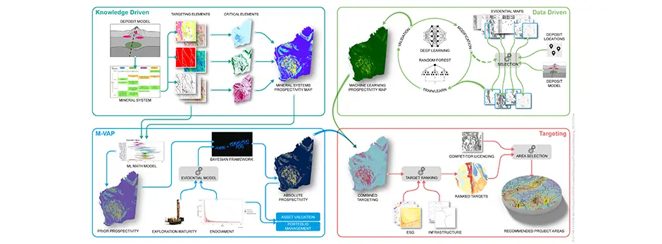
Prospectivity mapping approaches can be broadly categorised as knowledge-led or data-driven. Knowledge-led methods rely on experienced geologists recognising features in key spatial datasets that indicate deposit-forming geological processes occurred at favourable times in Earth’s history— the foundation of the mineral-systems concept. These models are particularly useful in data-poor regions where little or no exploration has been conducted. Known deposits are used only to validate the model, not to produce it.
Data-driven models integrate extensive datasets, known deposit locations, and machine-learning algorithms to identify patterns and correlations that predict where similar deposits may occur. These methods—and hybrid approaches that combine them with expert knowledge input—are generally more objective than purely knowledge-led ones but depend on high data density and a sufficient number of known deposits for model training.
For prospectivity analysis, SRK typically uses a hybrid approach or develops both model types for comparison. The approaches are considered complementary, as demonstrated in a recent prospectivity- mapping project across Western Australia (WA).
A mineral-system model was developed from first principles for lithium-caesium-tantalum (LCT) pegmatites, which occur widely in Archaean greenstone belts across the Yilgarn and Pilbara cratons. Using a focused set of key datasets to map the critical elements and constituent processes of the mineral system, SRK produced a knowledge-led prospectivity map.
The extensive, high-quality geoscience coverage for WA also enabled development of a data-driven model. Both models, covering more than 2.5 million km², showed strong correlation with a bespoke database of LCT-pegmatite occurrences—and with each other.
Both models highlighted geologically favourable sections of greenstone belts where historical exploration had targeted gold or nickel, potentially not considering lithium prospects.
Comparing the outputs of the two approaches helped identify the effects of sparse data and gaps in deposit-model knowledge. In this way, the relative confidence or reliability of each model could be assessed.
Incorporating exploration-maturity and endowment analysis enabled SRK to estimate absolute prospectivity—the statistical probability of discovering a deposit of a specified size within a given area.