Integrating artisanal mining data can greatly assist exploration teams in greenfield programs by helping identify and locate primary gold deposits. Artisanal mining activities are often encountered in greenfield programs and in areas of large-scale mechanized mining. Artisanal miners in many countries are often involved in informal, small-scale gold recovery throughout their lives, representing multi-generational mining traditions within local communities. Over time, these miners have developed a wealth of knowledge about the distribution of gold within various systems from which it is recovered.
Historically, geologists have been cautious or have avoided engagement with artisanal miners due to concerns, including: security risks and operational safety; informal land access and ownership complexities; environmental and social risks; lack of formal production records; and potential conflict with mining permits and regulatory framework.
However, when managed responsibly, engagement with artisanal mining communities can yield valuable geological insights that significantly enhance exploration targeting and interpretation in the search for a primary gold deposit.
Artisanal miners primarily exploit secondary gold deposits with hand tools, gold pans, sieves and crude washing tables. These miners focus on modern active drainage systems, ancient river channels, and terrace deposits. It is less common for them to work on primary deposits, and where they do, the focus is often within laterite and saprolite. Gold distribution within the secondary environments is inherently complex and highly variable. In some systems, gold concentrations may remain static where the primary source has been completely eroded. In contrast, other systems may experience seasonal or flood-driven recharge, during which gold continues to be liberated from an active primary source or sources into the secondary environment.
It is important to appreciate that drainage systems hosting the gold are dynamic environments and that gold is often redistributed over time. Drainage dynamics and flow directions can change multiple times and even reverse, resulting in a complex distribution of gold, and therefore, locating a proximal primary source may be very challenging. The most important factors supporting exploration targeting in artisanal mining environments include:
1. Confirmed recovery of gold within the area of interest; 2. Sustained artisanal mining activity over multiple years; 3. Gold grain morphology indicating minimal transport; 4. Preservation of associated minerals providing insight into primary source lithologies; 5. Artisanal mining occurring directly within or adjacent to primary mineralized zones
Review of artisanal mining activities using Google Earth, satellite imagery, and historical aerial photography allows for exploration geologists to evaluate the spatial evolution of artisanal mining activity over time. The rapid relocation behaviour of artisanal miners when the ground becomes unproductive creates discernible spatial patterns that can effectively guide exploration targeting strategies. In addition, LIDAR surveys allow exploration teams to identify drainage features and historic mining areas obscured by vegetation.
The examination of gold grains recovered by artisanal miners provides essential information to exploration teams. Parameters such as the volume of gold recovered, grain-size distribution, and gold-grain morphology provide strong indications of source proximity and potential source-rock characteristics. Investigation of gold grains using a Scanning Electron Microscope (SEM) and Backscattered Electrons (BSE) imaging enables detailed morphological analysis, aiding in the classification and interpretation of textures preserved on recovered grains.
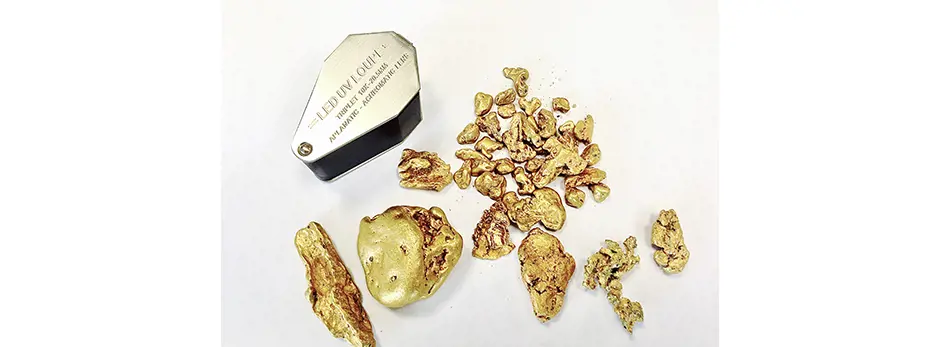
Angular, irregular grains with jagged morphology and the preservation of associated host minerals (quartz, carbonate, sulphides) typically indicate limited transport (< 3km) and proximity to the primary mineralization. In rare cases, delicate primary growth features and even sponge-like structures can be partially preserved.
Gold grains that have experienced significant transport (> 3km to 10s of km) from the primary source display very different morphology, characterized often by smooth, flattened disc-shaped grains, and they lack any associated gauge minerals. It is important to appreciate that although the size of gold grains can reflect transport distance, welding of grains can occur (up to 30mm – see photo below).
Artisanal mining activities and the investigation of gold grains recovered from small-scale mining operations may provide important data that can significantly inform early-stage greenfield exploration programs. Integration of artisanal mining data with geological mapping, geochemical surveys, structural interpretations, remote sensing and geophysics enhances the probability of identifying primary gold sources and refining exploration models.